Published: 01 December 2025
-
Select all|
-
LITHOFACIES PALAEOGEOG RAPHY AND SEDIMENTOLOGYFlume simulation experiment of architecture of braided alluvial fans under episodic flood conditions2025, 27(6): 1351-1367. https://doi.org/10.7605/gdlxb.2025.097
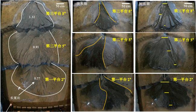
The sedimentary evolution and modification of braided alluvial fans under episodic flood conditions play a key role in shaping the reservoir architecture and distribution patterns of these dynamic systems. However,the evolutionary processes,formation mechanisms,and controlling factors of the architecture of this type of alluvial fan remain unclear. Through flume simulation experiments,this study simulated the evolution and reworking process of different geomorphic units and sedimentary architectures of braided alluvial fans under episodic flood conditions. It also investigated various construction and reworking mechanisms of episodic flood fluids with different flow states,clarifying the evolutionary process and architectural characteristics of braided alluvial fans under episodic flood conditions. The research shows that: (1)Under episodic flood conditions,the topographic slope and sediment supply are the main controlling factors affecting the morphology of the fan. As the slope increases,the fan tends to grow axially,with an increasing length-to-width ratio. An increase in sediment supply leads to an expansion in fan area but has little effect on the length-to-width ratio. An increase in the number of sediment sources results in more planar intersection areas between individual fans,reducing the length-to-width ratio of each fan.(2)The transformation of fluid properties between flood and inter-flood periods is a crucial factor controlling sedimentary architecture. During the flood period, sheet flow deposits predominantly occur in the fan apex and upper-middle parts. As the flood disperses and weakens,the lower-middle parts and fan edges transition to braided stream deposits. During the inter-flood period,persistent trickling streams flow through confined braided channels,reworking the flood gravity flow deposits formed during the previous flood period,resulting in strip-shaped braided channel deposits. The positions of transformation from sheet flow to unrestricted braided flow and from unrestricted braided flow to runoff are controlled by the flood flow velocity,sediment supply amount,and topographic slope.(3)The sheet flow deposits formed during the flood period are frequently reworked and superimposed by braided channel deposits formed during the inter-flood period,forming a complex sedimentary architecture of braided alluvial fans under episodic flood conditions in both time and space. Based on the results of flume simulation experiments,combined with the field investigation and anatomy of the Baiyang River alluvial fan,a sedimentary architecture model for braided alluvial fans under episodic flood conditions was established. This research not only enriches the sedimentological theory of alluvial fans and improves the analysis of their formation mechanisms,but also has significant practical value for the prediction of reservoirs of this type of alluvial fan.
-
LITHOFACIES PALAEOGEOG RAPHY AND SEDIMENTOLOGY2025, 27(6): 1368-1399. https://doi.org/10.7605/gdlxb.2025.084
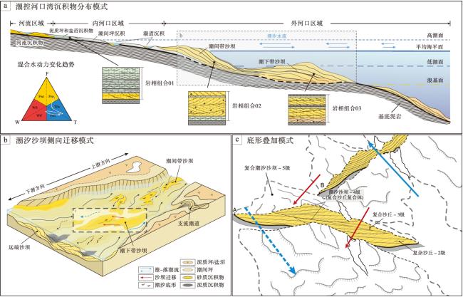
In the classification of clastic coastal depositional systems,tide-dominated estuaries hold significance equivalent to open tidal flats and tide-dominated deltas,representing an end-member of tidal environments. Sustained increases in accommodation and underfilled depositional conditions make estuaries favorable sites for the sandy sediment accumulation. Mixed hydrodynamic conditions control the sediment redistribution processes,while local variations in flow energy significantly affect the spatial distribution patterns of sand and mud components. These factors lead to a greater diversity of lithofacies types and lithofacies associations and relatively complex internal sedimentary structures. Therefore,this study integrates the sedimentary palaeogeographic research of the M1 Sandstone Member,Oriente Basin and the outcrop studies of the Bearreraig Sandstone Member,Isle of Skye,focusing on the systematic dissection of multi-level sedimentary architecture within tide-dominated estuaries. The study explores the controlling mechanisms behind the development of sequence-, sedimentary-, and bedform-scale architectures,and establishes a classification scheme for tide-dominated estuaries,applicable to levels 0-8.The two tide-dominated stratigraphic units from the M1 Sandstone and the Bearreraig Sandstone—exhibit different tide-dominated environmental stacking patterns,reflecting the systematic control of the source supply intensity by differential subsidence processes on the architecture of sequence-scale sedimentary units at levels 7-8. Based on comprehensive sedimentary reservoir data,and through the sedimentary palaeogeographic reconstruction of the M1 Sandstone Member’s inherited tide-dominated estuarine environment,this study further elaborates on the regional distribution patterns and scale variation trends of the levels 4-6 sedimentary architecture under mixed-hydrodynamic processes. Results indicate that,during the transition of mixed-hydrodynamic conditions, increasing tidal influence drives a gradual transformation of sand-body architectures, from proximal discrete tidal point bars to more distal and continuous tidal sand bars. Tidal flat architecture units,in contrast,are primarily governed by specific water depth and flow velocity remaining relatively stable along marqinal-tidal-falt zones. Moreover, outcrop evidence from the Bearreraig Sandstone Member provides detailed insights into bedform-scale(levels 0-3) architectures,revealing the influence mechanisms of local flow conditions-including ancient tidal flow direction and tidal cycle—on the scale and structural complexity growth of small-scale sedimentary architecture units. This study summarizes the classification standards of architecture levels and architecture development styles in tide-dominated estuarine environments within clastic coastal systems,offering a model foundation for comparative research on sedimentary structures and architecture evolution in tide-dominated systems.
-
LITHOFACIES PALAEOGEOG RAPHY AND SEDIMENTOLOGY2025, 27(6): 1400-1419. https://doi.org/10.7605/gdlxb.2025.098
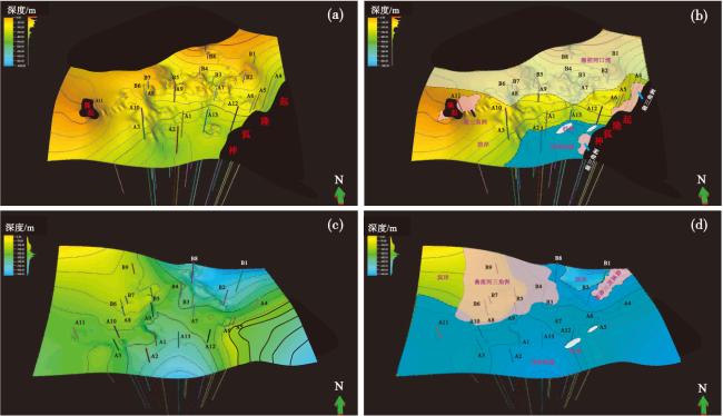
The Zhu-3 Depression is one of the main oil producing areas on the northern continental shelf of the South China Sea,but the exploration level is low,and issues such as unclear sediment source directions and ambiguous distribution ranges of sedimentary facies still exist. This study utilized core,drilling and logging,seismic data,as well as grain size and heavy mineral analysis data,to investigate the sedimentary system of the Zhujiang Formation in the central Zhu-3 Depression of the Pearl River Mouth Basin. The study identified five types of sedimentary facies,including tidal controlled estuary,meandering river delta,fan delta,shore and shallow sea shelf facies.The main sediment sources in the study area are from the northwest and northeast,while the secondary source is from the Shenhu Uplift in the southeast. During the early stages of sedimentation,fan deltas developed in the southeast,and tide-controlled estuary bay deposits formed in the semi-enclosed environment of the northwest. As the transgression from south to north gradually intensified,the Shenhu Uplift disappeared,and large-scale river-controlled meandering river deltas developed in the northwest,with the entire area experiencing a transgression process. Based on the comparison of tidal-controlled and fluvial-controlled sedimentary characteristics,the study summarized the sedimentary model and identified sediment supply,relative sea-level changes,and paleogeography as the main controlling factors of sedimentation.
-
LITHOFACIES PALAEOGEOG RAPHY AND SEDIMENTOLOGY2025, 27(6): 1420-1433. https://doi.org/10.7605/gdlxb.2025.095
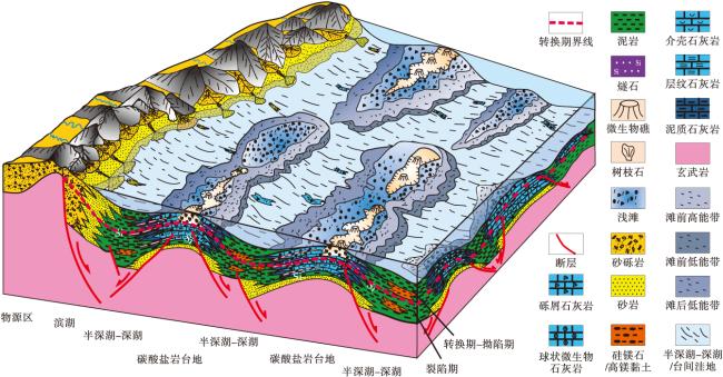
The Lower Cretaceous pre-salt section of the Great Campos Basin in eastern Brazil is rich in oil and gas resources,however,the understanding of the sedimentary characteristics and evolution of the strata remains limited. Based on core,thin section,logging and seismic data,combined with previous studies,this paper takes the Lower Cretaceous Barremian-Aptian pre-salt strata of the Great Campos Basin as the research object. Four sequence boundaries were identified in the target horizon,and three third-order sequences were divided. Within the sequence stratigraphic framework,the sedimentary characteristics and evolutionary processes of each systems tract were analyzed. The results show that the target strata contain lacustrine,lakeshore,shallow-lake,semi-deep lake-deep,lake sedimentary subfacies,gray mud flat,low energy zone behind the beach,shoal,reef,high energy zone in front of the beach,low energy zone in front of the beach,inter-platform depression,semi-deep lake-deep lake mud. The SQ1 sequence mainly developed during the rifting stage of the lake basin. The lake basin was relatively deep and mostly developed isolated lacustrine carbonate platforms. The SQ2 sequence developed during the transitional stage from rifting to depression,during which the isolated platform gradually coalesced. The SQ3 sequence developed in the depression stage,when the water body of the lake basin became shallower and the carbonate platforms expanded from isolated to lately connected systems. The sedimentary evolution of the Pre-salt section in the Great Campos Basin indicates that during the Barremian-Aptian period of the Early Cretaceous,the water body of the Great Campos Basin gradually became shallower,and the early isolated carbonate platforms evolved into extensive connected platforms. The reef microfacies along the platform margins began to develop on a large scale from the depression stage onward.
-
LITHOFACIES PALAEOGEOG RAPHY AND SEDIMENTOLOGY2025, 27(6): 1434-1451. https://doi.org/10.7605/gdlxb.2025.065
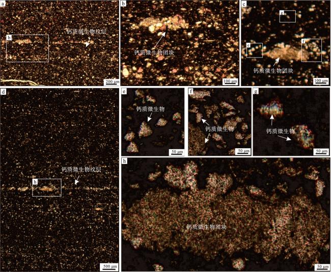
The Wufeng and Longmaxi formations are the key shale gas-enriched lithofacies in the Sichuan Basin,drawing significant attention to its sedimentary characteristics and genetic mechanisms. This study,employing MaipSCAN artificial intelligence electron microscopy mineral scanning,thin sections,field emission scanning electron microscopy,and helium ion microscopy techniques,reveals the mineral composition and vertical as well as horizontal distribution characteristics of the siliceous shale in the Zhaotong-Taiyang area of the Wufeng and Longmaxi formations. The research indicates that the siliceous shale in this region exhibits stable and widespread thickness,with major minerals including quartz,feldspar,clay,pyrite,calcite,and dolomite. Vertically,the silicon content decreases gradually,while the calcium minerals increase and clay minerals first decrease and then increase. Horizontally,the mineral distribution trends between different wells are consistent,with high silicon content mainly concentrated in the Long 1-11and Long 1-12 sub-layers,where the overall silica content exceeds 50%,representing a concentrated development zone of biogenic siliceous shale. The shale displays two types of laminations,mud laminae and silt laminae. The silt laminae exhibit coarser grains, characterized by an alternation of radiolarian laminae and calcareous. The radiolarian and enriched layers exhibit a lack of grain size sorting,random distribution of radiolarian tests of different sizes,high silicon content,and continuous distribution. In contrast,the calcareous algae-enriched layers appear as cohesive clusters with irregular external morphology,internally showing flocculent characteristics with varying particle sizes,discontinuous,platy,parallel,and rapidly changing thickness features. The study highlights that the formation of siliceous shale is influenced by rapid transgression and volcanic activities,regulating nutrient and seawater chemical property changes,impacting ecological niches and conditions,leading to the formation of different types of laminations. Siliceous shale,characterized by high silicon content,high organic matter content,excellent pore connectivity,good brittleness,and strong fracturability,emerges as a primary target for shale gas exploration.
-
LITHOFACIES PALAEOGEOG RAPHY AND SEDIMENTOLOGY2025, 27(6): 1452-1465. https://doi.org/10.7605/gdlxb.2025.080
Petrological evidence was acquired by orderly connections such as core,optical microscopy,electron probe microscopy and MAPS technology,in order to analyse the formation process of the Guanyinqiao Bed in the top of the Upper Ordovician Wufeng Formation in Sichuan Basin and its adjacent area. The results indicate that the formation process of the Guanyinqiao Bed was divided into two subprocesses and seven stages. The sedimentary subprocess went through three stages in sequence: gravity flow in shore,gravity flow in shallow sea and deep-water sandy-muddy debris flow. The four stages of the diagenetic subprocess were generally characterized by strong compaction and pressure solution,as well as the transformation of sedimentary organic matter into the porous pyrobitumen and the nonporous pyrobitumen. Based on integrating petrological features,the Guanyinqiao Bed was characterized as the deep-water sandy-muddy debris flow with complex structures formed by four subsystems: terrestrial clasts,shallow sea bioclasts,deep-water bio-clasts and organic matters. It is recommended to comprehensively apply outcrop,core,optical microscopy,electron probe microscopy and MAPS technology to systematically study the sedimentary environment and facies of the Ordovician-Silurian boundary strata in South China and even globally.
-
LITHOFACIES PALAEOGEOG RAPHY AND SEDIMENTOLOGY2025, 27(6): 1466-1484. https://doi.org/10.7605/gdlxb.2025.079
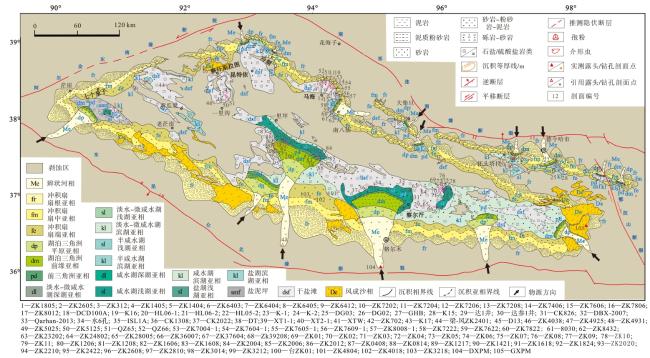
The Qaidam Basin is located at the junction of the Paleo-Asian tectonic domain and the Tethyan-Himalayan tectonic domain,characterized by a distinctive basin-mountain structural pattern. The Cenozoic strata in the basin were well developed,preserving a continuous and complete sedimentary record from the early Cenozoic to the Quaternary. Clarifying the Holocene stratigraphic framework and lithofacies-palaeogeography of the Qaidam Basin,and analyzing the history of sedimentary facies evolution,are of great significance for achieving new breakthroughs in salt mineral exploration within the basin. Based on a comparative analysis of lithologic facies and stratigraphic correlations from 103 borehole sections and 4 outcrop sections,a comprehensive study of the Holocene sedimentary facies of the Qaidam Basin was conducted. The results show that five types sedimentary facies developed in Qaidam Basin: alluvial fan,braided river,eolian sand,lacustrine delta and lake. The alluvial-fan facies developed along the basin margins,while the braided-river facies were mainly distributed across the intrabasin plains. Small lakes within the basin primarily formed salt-lake dry-flat deposits,accompanied locally by shoreline and shallow-lake subfacies. Influenced by the climatic variations of the Marine Isotope Stage(MIS)periods,the intrabasin salt lakes gradually dried up and disappeared. Consequently,the chemical deposition within the dry salt flat expanded further,leading to the progressive formation of large-scale evaporite(salt)deposits.
-
LITHOFACIES PALAEOGEOG RAPHY AND SEDIMENTOLOGY2025, 27(6): 1485-1499. https://doi.org/10.7605/gdlxb.2025.087
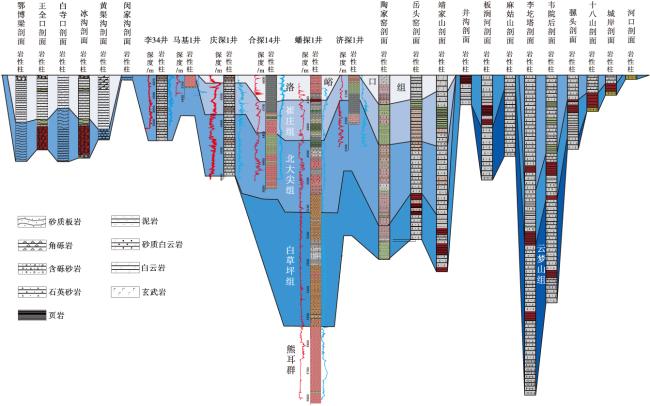
During the Meso- to Neoproterozoic,the Ordos Basin was influenced by rifting activities,leading to the deposition of the Changcheng System’s Xiong'er Group in the Ruyang and Ordos regions,and the Changzhougou to Dahongyu Formations in the Yanliao area. Although previous studies established a unified stratigraphic framework,regional stratigraphic correlations and internal evolutionary patterns remain debated due to early complex rifting. By integrating logging and coring data,regional 2D seismic reflection profiles,lithological analyses,and geochronological tests,this study clarifies the internal stratigraphic correlations of the Changcheng System in the Ordos Basin. Results show that Mesoproterozoic rifting in the Ruyang region’s Xiong'er Basin initiated at~1800 Ma,while rifting in the Ordos Basin’s southwestern Huating area began slightly later(>1759 Ma),with subsequent eastward migration of tectonic activity. After Xiong'er Group deposition,rifting ceased in the Ordos Basin,transitioning to a subsidence phase marked by the Baiyucao Formation of the Ruyang Group,whereas the Xiong'er Basin’s rifting center shifted northeastward. During Beidajian Formation deposition,the Yanliao Rift formed,initiating Changzhougou Formation sedimentation in Yanliao,while the Ordos Basin’s Changcheng System reached its maximum extent. A brief depositional hiatus,evidenced by an unconformity in seismic profiles,followed in the Ordos Basin. Widespread regression occurred during Cuizhuang and Luoyukou Formation deposition,reducing sedimentary coverage. Integrated chronostratigraphic and depositional center analyses suggest that the North China Craton’s stratigraphic evolution,driven by rifting,migrated southward from the craton’s southern margin toward the Taihang-Yanliao regions.
-
TECTONOPALAEOGEOGRAPHY AND PALAEOTECTONICS2025, 27(6): 1500-1515. https://doi.org/10.7605/gdlxb.2025.096
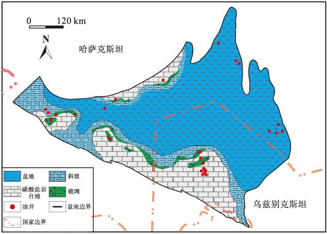
The North Ustyurt Basin,a pivotal oil and gas-bearing region in Central Asia,possesses significant exploration potential. Nevertheless,the Paleozoic strata within the basin are deeply buried,resulting in a relatively low exploration degree and insufficient research. This study aims to elucidate the tectonic evolution and sedimentary characteristics of the basin during the Late Paleozoic. Geographically,the North Ustyurt Basin is located at the junction of the northern margin of the Tethys tectonic domain and the Paleo-Asian Ocean tectonic domain. Its tectonic evolution was intricately influenced by the opening and closure of the Paleo-Tethys and Paleo-Ural Oceans,and it underwent six distinct stages: basement formation,passive continental margin,rifting,post-rifting,compression,and Neogene subsidence. During the Late Paleozoic passive continental margin stage,the basin was mainly affected by the closure of the Ural Ocean,which led to regional compressional uplift. The Carboniferous strata exhibit a characteristic west-thick,east-thin distribution,with greater thickness in the north. Drilling data from the southern region reveal the presence of the crystalline basement. The Permian Permian succession shows notable thickness variations,with thicker deposits in the northeast and thinner accumulations in the central and western parts of the basin. A significant unconformity exists between the Permian and Triassic strata. Throughout the Late Paleozoic,the basin’s water body gradually became shallower,experiencing four distinct transgressive-regressive cycles,that controlled the variations in accommodation space. The sedimentary facies types mainly include braided river,deltaic,clastic shoreline,restricted platform facies,and open platform facies. Lithofacies-paleogeographic analysis indicates that from the Late Devonian to Early Carboniferous,deep-water basins and slope deposits were developed. During the Late Carboniferous,the southern and northern basin margins were dominated by shallow-marine carbonate platforms,whereas the Permian deposits succession was primarily composed of transitional to continental sediments. This study systematically analyzes the tectonic evolution,sedimentary filling patterns,and the distribution of hydrocarbon source rocks and reservoirs in the study area. The findings provide a robust scientific foundation for subsequent oil and gas exploration strategies,block evaluation,and the optimization of exploration well placement.
-
TECTONOPALAEOGEOGRAPHY AND PALAEOTECTONICS2025, 27(6): 1516-1531. https://doi.org/10.7605/gdlxb.2025.074
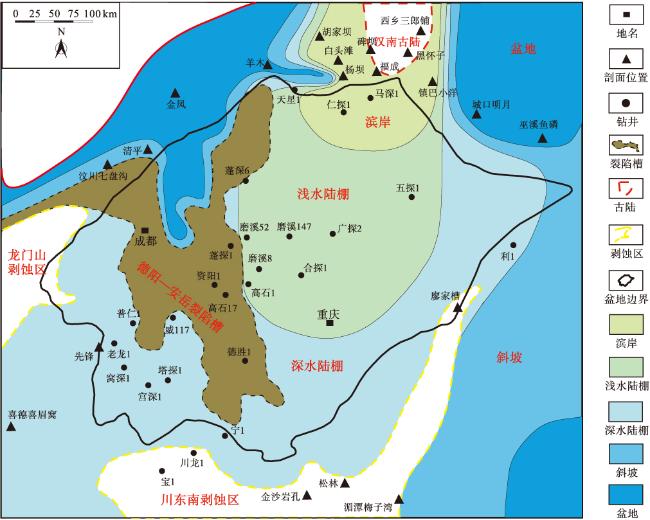
The distribution of lithofacies and sedimentary facies within the third member of the Dengying Formation in the Sichuan Basin remains a topic of debate,hindering a comprehensive understanding of the tectonic framework of that period and limiting further exploration of oil and gas resources. To address this issue,this study conducts an in-depth analysis of multiple outcrop sections and drill cores from the third member of the Dengying Formation in the Sichuan Basin. Three primary depositional environments have been identified: deep-water shelf,shallow-water shelf,and coastal zones. The deep-water shelf environment is characterized by a tranquil setting,with shale and mudstone as the dominant lithologies. The shallow-water shelf,influenced by storm waves and backflow currents,is marked by the deposition of sandstone,siltstone,and mixed sedimentary rocks,which commonly exhibit storm-induced structures such as hummocky cross-bedding,graded bedding,and scour surfaces. The coastal zone,controlled by wave and tidal processes,with sandstone as the predominant lithology,is characterized by the well-developed cross-bedding. Furthermore,in the Xixiang-Nanzheng area,the fourth member of the Dengying Formation directly overlies the basement,indicating the presence of a palaeocontinent during the deposition of the third member. Based on the dominant facies identified from typical sections and using the single-factor method,a sedimentary facies distribution map for the third member of the Dengying Formation in the Sichuan Basin has been constructed. This map reveals a terrigenous siliciclastic-dominated epeiric marine environment controlled by the Hannan paleocontinent. As one moves away from the Hannan paleocontinent,the depositional environments transition sequentially from coastal to shallow-water shelf and then to deep-water shelf settings. Overall,the farther one is from the paleocontinent,the less clastic material is supplied,resulting in finer sediment grain size and thinner depositional thickness. This depositional pattern reflects the extensional tectonic background of the Sichuan Basin during the Dengying period. During this period,the South China Plate was drifting and did not receive terrestrial supplies from other plates. By the Early Cambrian,the northwest margin of the Sichuan Basin gradually approached the Gondwana continent,transitioning the tectonic background from extensional to compressional. This collisional orogeny influenced the depositional pattern of the Canglangpu Formation in the Sichuan Basin,resulting in an eastward-dipping geomorphology where clastic rocks change into carbonate rocks from west to east.
-
TECTONOPALAEOGEOGRAPHY AND PALAEOTECTONICS2025, 27(6): 1532-1551. https://doi.org/10.7605/gdlxb.2025.099
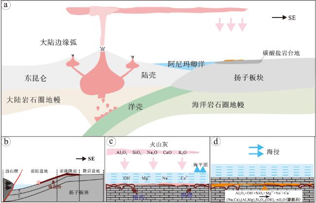
The Middle to Late Triassic period is a critical phase characterized by the subduction of the Paleo-Tethys Ocean and the Indosinian orogeny,which triggered widespread volcanic activity. Volcanic tuff,altered to bentonite through sedimentary processes,plays a crucial role in stratigraphic dating and tectonic interpretation. The bentonite layer studied is found within the top of the Middle Triassic Tianjingshan Formation in the western Sichuan Basin. Comprehensive analyses,including petrology,clay mineralogy,major and trace elements,and zircon Hf isotopes,are conducted on this bentonite layer. The bentonite is mainly composed of montmorillonite with minor amounts of kaolinite. Geochemical analysis reveals that large ion lithophile elements are more enriched compared to high field strength elements. Zircon Hf isotope analysis indicates εHf(t)values ranging from -2.35 to 0.95,reflecting typical crust-mantle mixing characteristics. Model ages(
${T}_{DM}^{C}$ )suggest a Mesoproterozoic provenance,ranging from 1.21 Ga to 1.41 Ga. Based on these geochemical features,the bentonite layer at the top of the Tianjingshan Formation is inferred to have originated from an acidic source magma. The magma source region may exhibit arc-related characteristics formed by the subduction of young oceanic crust,with the magmatic evolution likely involving partial melting and crust-mantle magma mixing. A comparison with records of coeval magmatic rocks in surrounding regions indicates that the bentonite layer of the Tianjingshan Formation shares similar Hf isotopic and geochemical characteristics with magmatic rocks from the eastern segment of the East Kunlun. This indicates a common magmatic source and potentially reflect similar basement properties and tectonic affinities. These findings provide significant insights into the early Indosinian tectonic evolution along the northwestern margin of the Yangtze Block and offer critical evidence for the northward subduction and eventual closure of the Animaqing branch of the Paleo-Tethys Ocean. -
BIOPALAEOGEOGRAPHY AND PALAEOECOLOGY2025, 27(6): 1552-1563. https://doi.org/10.7605/gdlxb.2025.092
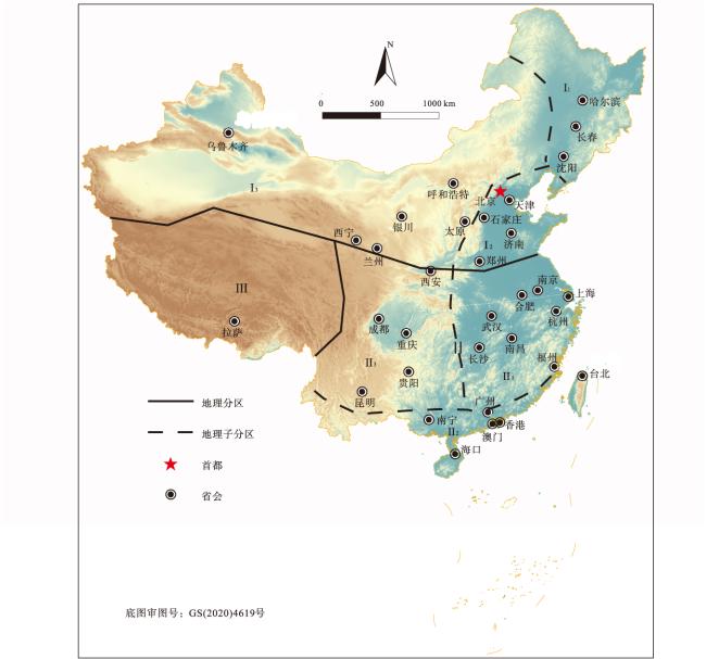
The Quaternary glacial and interglacial cycles have significantly influenced vegetation distribution,biodiversity,and ecosystems in China. Based on pollen analysis as the main palaeobotanical research proxy,and integrated with modern floristic distribution patterns,this study examines the spatiotemporal distribution and evolutionary characteristics of Quaternary vegetation in China within the framework of vegetation-climate-environment interactions. During the Quaternary,paleo-vegetation in China exhibited significant variation in species richness,characterized by distinct zonal differentiation across latitudinal gradients,differences between eastern and western regions,and variations along altitudinal gradients. The findings indicate that vegetation evolution was closely linked to past climate changes and was influenced by environmental factors such as tectonic activity and topography,leading to cyclical temporal fluctuations and spatially synchronous migrations. Furthermore,this study briefly explores the formation of historical plant refugia and identifies potential refugia under Quaternary climate oscillations in China,thereby providing a scientific basis for assessing plant diversity and guiding ecological conservation. This comprehensive synthesis of Quaternary phytogeography in China holds great significance for understanding long-term vegetation evolution and improving future ecological projections. Future investigations should adopt interdisciplinary approaches and utilize multiple proxies to enhance the robustness of reconstructions.
-
BIOPALAEOGEOGRAPHY AND PALAEOECOLOGY2025, 27(6): 1564-1576. https://doi.org/10.7605/gdlxb.2025.055
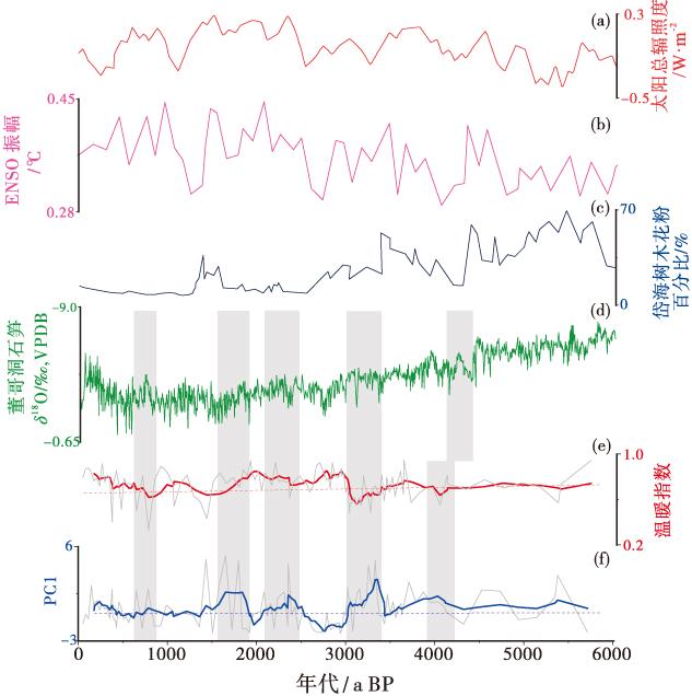
Poyang Lake,situated in the East Asian monsoon region,is one of the regions most sensitive to Holocene climate change. Consequently,investigating the climatic variations of Poyang Lake since the Holocene holds significant importance. Phytolith analysis offers distinct advantages for reconstructing paleoclimate,and abundant phytoliths have been retrieved from sedimentary cores of Poyang Lake. However,there has been limited in-depth exploration into the mechanisms of climate evolution and regional comparisons in phytolith-based paleoclimate studies of Poyang Lake during the mid-to-late Holocene. To reconstruct the climate evolution process of Poyang Lake over the past 5700 years and examine its underlying mechanisms,phytoliths from the ZK01 borehole were utilized as indicators. Principal component analysis was employed to analyze the phytolith assemblages,yielding principal component scores that reflect changes in climate wetness and dryness. Based on variations in phytolith assemblages and the Warmth Index,three major climatic stages were identified. The findings indicate: (1)Over the past 5,700 years,four relatively dry periods and three relatively humid periods have occurred in the Poyang Lake area. Phytolith records show sensitivity to global events such as the 4.2 ka event and the Little Ice Age.(2)There is a good correspondence between phytolith records in the Poyang Lake area and stalagmite δ18O records that respond to East Asian summer monsoon(EASM)variability. When the EASM weakens,the Poyang Lake region tends to be wetter,and vice versa.(3)The phytolith records from the Poyang Lake region,situated in the southern part of the East Asian monsoon area,exhibit a degree of comparability with pollen-based precipitation records from the Daihai region in North China. This suggests an anti-phase spatial pattern of precipitation between the southern and northern regions of eastern China’s monsoon area during the mid-to late Holocene.(4)Since the mid-Holocene,ENSO activity has influenced the hydrological climate of the Poyang Lake region. Periods of increased ENSO intensity often coincide with humid climate phases in the Poyang Lake region,suggesting that variability in ENSO intensity may reflect changes in the strength of El Niño or La Niña.
-
BIOPALAEOGEOGRAPHY AND PALAEOECOLOGY2025, 27(6): 1577-1589. https://doi.org/10.7605/gdlxb.2025.040
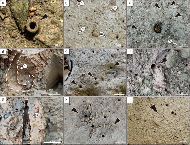
Biogenic traces are robust indicators of environmental conditions. A comprehensive analysis of biogenic traces and environmental characteristics in the distributary channels of the Pearl River Delta Plain can provide valuable insights into the nature of biological traces and aid in interpreting paleo-deltaic channels. This study focuses on three primary distributary channels of the modern Pearl River Delta Plain. Sedimentological and ichnological investigations were conducted at 74 sampling sites throughout the study area,which included field photography to quantify ichnodiversity and abundance,salinity measurements,grain size analyses,and CT scanning with three-dimensional reconstruction of cores. The results indicate that: (1)The principal trace-makers identified in the study area include crabs,Perinereis aibuhitensis,Corbicula fluminea,Pomacea canaliculata,Periophthalmus cantonensis,and birds. These organisms produce a variety of endobenthic traces(I-,U-,and Y-shaped)and epibenthic traces(crawling,feeding,and defecation traces). Trace assemblages generally exhibit simple morphologies,predominantly subvertical or horizontal orientations relative to the bedding plane,and are characterized by sparse and uneven distributions.(2)Salinity,grain size,and sedimentation rate are the primary physicochemical factors influencing the distribution of biogenic traces in modern Pearl River Delta sediments.(3)Modern analog studies are essential for understanding the acient fluvial-tidal transition zone. Endobenthic and epibenthic traces observed in the study area exhibit similarities to trace fossils such as Skolithos,Psilonichnus,Arenicolites,Polykladichnus,and Planolites,reflecting a mix of Psilonichnus,Skolithos,and Scoyenia ichnofacies. These findings are instrumental in identifying and exploring the fluvial-tidal transition zone within the palaeo-delta channel.
-
REVIEW2025, 27(6): 1590-1606. https://doi.org/10.7605/gdlxb.2025.086
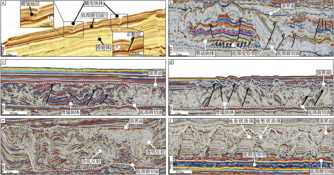
Submarine landslides and their associated high-density debris flows and turbidity currents constitute an important component of deep-sea sedimentary basins worldwide. Aiming at exploring the petroleum implications of submarine landslide deposits,the lithological,petrophysical,and geotechnical properties of submarine landslide deposits are summarized based on newly-collected petrophysical logging data,geotechnical experiments and stratigraphic logging data. Submarine landslide deposits are characterized by: higher density,resistivity,P-wave velocity,and undrained shear strength,along with low porosity,water content,and disorderly distributed dip angles and dip direction azimuths. These features indicate that submarine landslide deposits undergo more intense internal deformation and compaction compared to surrounding undisturbed strata. Abnormally high P-wave velocity and resistivity responses are observed in an interval(15 to 30 meters)above the basal shear surface of a single submarine landslide deposit,which is interpreted as the most consolidated and condensed structural unit called basal shear zone(BSZ). BSZ can serve as natural seals to effectively inhibit the escape of deep-sea hydrocarbons and gas hydrates. Additionally,muddy BSZ combined with hydroplaning effects significantly reduces the erosional capacity of submarine landslides,allowing sandy layers within the deposits to preserve their structural integrity during transport and thereby enhancing their potential as high-quality deep-sea reservoirs. Investigating the physical properties and petroleum geological implications of submarine landslide deposits contributes to understanding the accumulation mechanisms of conventional hydrocarbons and gas hydrates in deep-sea environments,providing critical geological insights for future energy exploration,development,and carbon sequestration site selection.
-
REVIEW2025, 27(6): 1607-1626. https://doi.org/10.7605/gdlxb.2025.060
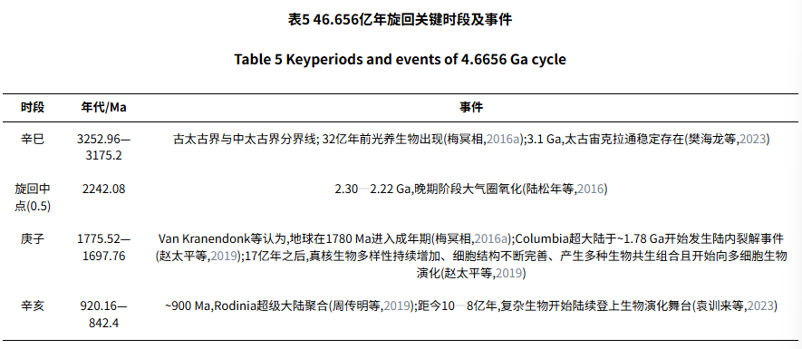
Based on the traditional Chinese Ganzhi Chronology,the Sixty-Jiazi Chronology,and the 3,600-year cycle theory from Traditional Chinese Medicine,this study deduces cycles of 216000 years,12.96 million years,777.6 million years,and 46.656 billion years. The universe’s lifespan is assumed to be 46.656 billion years. According to the latest scientific advances,the Big Bang occurred 13.81536 billion years ago,and the age of the Solar System and the Earth is estimated at 4.57488 billion years. By the Ten Heavenly Stems,the universe is divided into ten 4.6656-billion-year cycles. On this basis,first,by the Sixty-Jiazi method,four key points in the Earth’s 4.57488-billion-year history are identified as Xinsi(0.3),the midpoint of the cycle(0.5;the boundary between Guisi and Jiawu),Gengzi(0.618),and Xinhai(0.8),which correspond to geological events. Second,using the golden-ratio method,we repeatedly partition the 4.57488-billion-year history to identify golden-ratio points and compare them with geological events. Third,the Earth’s evolutionary history is divided into six major cycles using a 777.6-million-year periodicity,namely 4574.88-3797.28 Ma,3797.28-3019.68 Ma,3019.68-2242.08 Ma,2242.08-1464.48 Ma,1464.48-686.88 Ma,and 686.88 Ma to present. The key nodes of each 777.6-million-year cycle,such as Xinsi,Gengzi,and Xinhai,are analyzed. Fourthly,following the concept of “one yin and one yang is called the Tao”,two 777.6-million-year cycles—comprising 120 segments of 12.96 million years—are taken as one cycle. The 74th 12.96-million-year segment(the golden-ratio position)is identified to examine the biological and geological changes during this period. Finally,the most recent 777.6-million-year cycle is subdivided into 12.96-million-year intervals by the Sixty-Jiazi. The golden-ratio point of each 12.96-million-year interval is identified and compared with the subdivisions of the geological time scale,from which a model of Earth’s evolutionary history is constructed.


